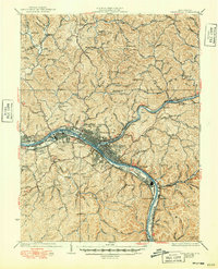
1935 Map of Charleston
USGS Topo · Published 1949About this map
Charleston serves as the focal point of this survey, where the convergence of the Kanawha River and the Elk river valley established a major transportation hub by the mid-1930s. The landscape is deeply influenced by heavy industry and military activity, notably the large U.S. Navy Reservation situated along the river bend near South Charleston. This era captures the city's expansion into residential districts like South Hills and South Park, while the surrounding hills remain dotted with small rural landmarks.
Find a feature on this map
136 named features on this map. Tap any name to fly to it.
Don’t see what you’re looking for? This feature index may not catch every label — zoom into the map to look around manually.
Map Details
Editions of this 1935 Charleston Map
2 editions found
Other maps of this area

1897 · Kanawha Falls
USGS Topo · 1:125,000

1899 · Charleston
USGS Topo · 1:125,000

1900 · Kanawha Falls
USGS Topo · 1:125,000

1901 · Kanawha Falls
USGS Topo · 1:125,000

1906 · Kenna
USGS Topo · 1:62,500

1906 · Winfield
USGS Topo · 1:62,500

1906 · Walton
USGS Topo · 1:62,500

1907 · Kenna
USGS Topo · 1:62,500

1907 · Walton
USGS Topo · 1:62,500

1907 · Clendenin
USGS Topo · 1:62,500