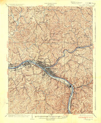
1936 Map of Charleston
USGS Topo · Published 1936About this map
The confluence of the Elk River and the Kanawha River anchors this detailed study of West Virginia’s capital region. By the mid-1930s, industrial and civic development had transformed the riverbanks, seen here in the dense grid of Charleston and the nearby U S Naval Reservation. The landscape is defined by the rigid topography of the surrounding hills, where dozens of one-room schoolhouses like Roxalana Sch and Tyler Sch served the hollows and ridge-top communities.
Find a feature on this map
96 named features on this map. Tap any name to fly to it.
Don’t see what you’re looking for? This feature index may not catch every label — zoom into the map to look around manually.
Map Details
Editions of this 1936 Charleston Map
This is the sole edition of this map. No revisions or reprints were ever made.
Other maps of this area

1897 · Kanawha Falls
USGS Topo · 1:125,000

1899 · Charleston
USGS Topo · 1:125,000

1900 · Kanawha Falls
USGS Topo · 1:125,000

1901 · Kanawha Falls
USGS Topo · 1:125,000

1906 · Kenna
USGS Topo · 1:62,500

1906 · Winfield
USGS Topo · 1:62,500

1906 · Walton
USGS Topo · 1:62,500

1907 · Kenna
USGS Topo · 1:62,500

1907 · Walton
USGS Topo · 1:62,500

1907 · Clendenin
USGS Topo · 1:62,500