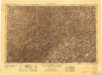
1954 Map of Charleston
USGS Topo · Published 1954About this map
The Kanawha River serves as the industrial and logistical spine of this mid-century portrait of West Virginia, where the state capital of Charleston is surrounded by a dense network of chemical plants and rail hubs including South Charleston, Nitro, and Saint Albans. The map reveals a landscape defined by the sharp transition from the river-bottom industrial corridor to the high ridges of the Allegheny Mountains in the east. Within the Monongahela National Forest, numerous peaks like Big Spruce Knob and Cold Knob dominate a region largely devoid of major settlements, contrasting with the river valley's activity.
Find a feature on this map
95 named features on this map. Tap any name to fly to it.
Don’t see what you’re looking for? This feature index may not catch every label — zoom into the map to look around manually.
Map Details
Editions of this 1954 Charleston Map
This is the sole edition of this map. No revisions or reprints were ever made.
Other maps of this area

1886 · St. George
USGS Topo · 1:125,000

1887 · Warfield
USGS Topo · 1:125,000

1887 · Hinton
USGS Topo · 1:125,000

1887 · Lewisburg
USGS Topo · 1:125,000

1889 · Nicholas
USGS Topo · 1:125,000

1889 · Beverly
USGS Topo · 1:125,000

1891 · Lewisburg
USGS Topo · 1:125,000

1891 · Nicholas
USGS Topo · 1:125,000

1891 · Huntersville
USGS Topo · 1:125,000

1891 · Oceana
USGS Topo · 1:125,000