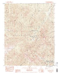
1984 Map of Charleston Peak
USGS Topo · Published 1984About this map
Spring Mountains recreation and conservation areas dominate this mid-1980s provisional survey of the high-elevation landscape in the Toiyabe National Forest. The settlement at Mt Charleston serves as the focal point for a network of backcountry paths, including the North Loop Trail and South Loop Trail, which provide access to the summit of Charleston Peak. The map highlights a significant infrastructure for seasonal residents and visitors, evidenced by the Lady of the Snows Camp and the Clark Co Youth Camp. Numerous drainages like Kyle Canyon and Lee Canyon illustrate the complex drainage patterns of the range. The inclusion of sites such as the Old Mill Picnic Area and the Lee FS Sta indicates the area's history of forest management and public use, while the presence of the Desert View Natural Environment Area reflects the ecological transitions unique to this Nevada mountain range.
Find a feature on this map
53 named features on this map. Tap any name to fly to it.
Don’t see what you’re looking for? This feature index may not catch every label — zoom into the map to look around manually.
Map Details
Editions of this 1984 Charleston Peak Map
2 editions found
Other maps of this area

1907 · Las Vegas
USGS Topo · 1:250,000

1908 · Las Vegas
USGS Topo · 1:250,000

1954 · Las Vegas
USGS Topo · 1:250,000

1957 · Las Vegas
USGS Topo · 1:250,000

1957 · Mt. Stirling
USGS Topo · 1:62,500

1957 · Charleston Peak
USGS Topo · 1:62,500

1957 · Mountain Springs
USGS Topo · 1:62,500
1958 · Pahrump
USGS Topo · 1:62,500

1959 · Las Vegas
USGS Topo · 1:250,000

1962 · Las Vegas
USGS Topo · 1:250,000