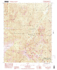
1984 Map of Charleston Peak
USGS Topo · Published 1984About this map
Toiyabe National Forest dominates this high-altitude landscape in the mid-1980s, centering on the prominent Charleston Peak. The survey reveals a concentration of recreational and seasonal infrastructure along the eastern slopes, particularly within Lee Canyon and Kyle Canyon. Settlement is clustered around the small community of Mt Charleston, which serves as a gateway to the surrounding wilderness.
Find a feature on this map
57 named features on this map. Tap any name to fly to it.
Don’t see what you’re looking for? This feature index may not catch every label — zoom into the map to look around manually.
Map Details
Editions of this 1984 Charleston Peak Map
2 editions found
Other maps of this area

1907 · Las Vegas
USGS Topo · 1:250,000

1908 · Las Vegas
USGS Topo · 1:250,000

1954 · Las Vegas
USGS Topo · 1:250,000

1957 · Las Vegas
USGS Topo · 1:250,000

1957 · Mt. Stirling
USGS Topo · 1:62,500

1957 · Charleston Peak
USGS Topo · 1:62,500

1957 · Mountain Springs
USGS Topo · 1:62,500
1958 · Pahrump
USGS Topo · 1:62,500

1959 · Las Vegas
USGS Topo · 1:250,000

1962 · Las Vegas
USGS Topo · 1:250,000