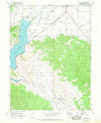
1966 Map of Charleston
USGS Topo · Published 1969About this map
Deer Creek Reservoir and the Provo River dominate the western portion of this mid-1960s survey, illustrating the complex water management of the Heber Valley. The landscape is defined by an intricate network of irrigation, including the Sagebrush and Spring Creek and Rio Grande Canal and the Upper Charleston Canal, which supported the agricultural settlements of Charleston and Daniels. To the south, Wallsburg sits at the head of Round Valley, where Main Creek and Little Main Creek converge.
Find a feature on this map
42 named features on this map. Tap any name to fly to it.
Don’t see what you’re looking for? This feature index may not catch every label — zoom into the map to look around manually.
Map Details
Editions of this 1966 Charleston Map
This is the sole edition of this map. No revisions or reprints were ever made.
Other maps of this area

1885 · Salt Lake
USGS Topo · 1:250,000

1900 · Coalville
USGS Topo · 1:125,000

1903 · Coalville
USGS Topo · 1:125,000

1907 · Strawberry Valley
USGS Topo · 1:125,000

1909 · Strawberry Valley
USGS Topo · 1:125,000

1925 · Ft. Douglas
USGS Topo · 1:125,000

1928 · Ft. Douglas
USGS Topo · 1:125,000

1948 · Orem
USGS Topo · 1:62,500

1948 · Aspen Grove
USGS Topo · 1:24,000

1948 · Bridal Veil Falls
USGS Topo · 1:24,000