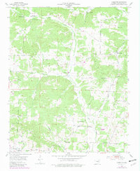
1954 Map of Charlotte
USGS Topo · Published 1982About this map
Charlotte sits at the center of this rural Independence County landscape, where the rolling hills are defined by the winding paths of Curia Creek and Dota Creek. The area’s mid-century character is preserved through an extensive network of family and community landmarks, including numerous small burial grounds such as Convenience Cem, McDonald Cem, and Batman Cem. These sites, alongside rural congregations at Antioch Ch and Oak Hill Ch, suggest a long-established settlement pattern rooted in the creek valleys.
Find a feature on this map
38 named features on this map. Tap any name to fly to it.
Don’t see what you’re looking for? This feature index may not catch every label — zoom into the map to look around manually.
Map Details
Editions of this 1954 Charlotte Map
2 editions found

Other maps of this area

1890 · Batesville
USGS Topo · 1:125,000

1891 · Batesville
USGS Topo · 1:125,000

1932 · Strawberry
USGS Topo · 1:62,500

1935 · Strawberry
USGS Topo · 1:62,500

1935 · Newport
USGS Topo · 1:62,500

1941 · Strawberry
USGS Topo · 1:62,500

1942 · Salado
USGS Topo · 1:31,680

1943 · Cave City
USGS Topo · 1:31,680

1943 · Sulphur Rock
USGS Topo · 1:31,680

1953 · Memphis
USGS Topo · 1:250,000