
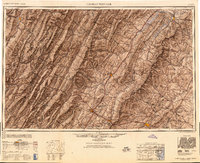
1949 Map of Charlottesville
USGS Topo · Published 1949About this map
Shenandoah Valley dominates this mid-century landscape, framed by the parallel ridgelines of the Blue Ridge and the Allegheny Mountains. The map illustrates the region's complex terrain and settlement patterns, highlighting the serpentine course of the South Fork Shenandoah River as it passes through Luray and Front Royal. Significant infrastructure of the late 1940s is evident, including the dense rail network of the Chesapeake and Ohio Railway and the Southern Railway, which converged at regional hubs like Charlottesville and Staunton. Within the George Washington National Forest and Monongahela National Forest, high peaks such as Spruce Knob and Reddish Knob mark the rugged western horizon. The inclusion of Shenandoah National Park and prominent gaps like Swift Run Gap and Rockfish Gap underscores the area's role as a critical corridor for both transit and preservation in the post-war era.
Find a feature on this map
136 named features on this map. Tap any name to fly to it.
Don’t see what you’re looking for? This feature index may not catch every label — zoom into the map to look around manually.
Map Details
Editions of this 1949 Charlottesville Map
2 editions found
Other maps of this area

1884 · Harpers Ferry
USGS Topo · 1:125,000

1886 · St. George
USGS Topo · 1:125,000

1887 · Spottsylvania
USGS Topo · 1:125,000

1887 · Lewisburg
USGS Topo · 1:125,000

1889 · Beverly
USGS Topo · 1:125,000

1890 · Goochland
USGS Topo · 1:125,000

1891 · Harpers Ferry
USGS Topo · 1:125,000

1891 · Palmyra
USGS Topo · 1:125,000

1891 · Lewisburg
USGS Topo · 1:125,000

1891 · Huntersville
USGS Topo · 1:125,000