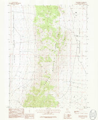
1986 Map of Chase Spring
USGS Topo · Published 1986About this map
Spruce Mountain Ridge dominates this mid-1980s landscape, serving as a high-altitude divide between two distinct basins. To the west lies the broad expanse of Clover Valley, while the eastern portion of the map is defined by Independence Valley. This topographic record provides a clear look at the region's ranching and resource-extraction heritage, noting several sites marked Prospect along the mountain flanks and a Gravel Pit on the valley floor. Water sources are critical in this arid Nevada environment, evidenced by the presence of Chase Spring, Mound Springs, and the seasonal path of Latham Creek. Human activity is sparse but notable, with isolated Corral sites and unimproved trails connecting the valley sinks to the higher elevations, illustrating the remote and utilitarian nature of this Elko County terrain.
Find a feature on this map
10 named features on this map. Tap any name to fly to it.
Don’t see what you’re looking for? This feature index may not catch every label — zoom into the map to look around manually.
Map Details
Editions of this 1986 Chase Spring Map
This is the sole edition of this map. No revisions or reprints were ever made.
Other maps of this area

1953 · Spruce Mountain
USGS Topo · 1:62,500

1953 · Spruce Mountain 4
USGS Topo · 1:62,500

1955 · Elko
USGS Topo · 1:250,000

1958 · Elko
USGS Topo · 1:250,000

1962 · Elko
USGS Topo · 1:250,000

1965 · Elko
USGS Topo · 1:250,000

1968 · Independence Valley SW
USGS Topo · 1:24,000

1968 · Snow Water Lake
USGS Topo · 1:24,000

1968 · Ventosa
USGS Topo · 1:24,000
1985 · Wendover
USGS Topo · 1:100,000