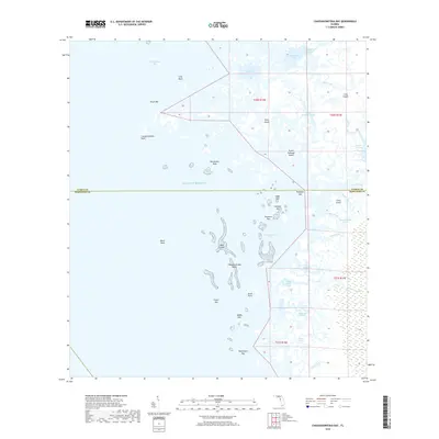
2018 Map of Chassahowitzka Bay
USGS Topo · Published 2018About this map
The Gulf coast of Florida where Citrus and Hernando counties meet is defined by a complex labyrinth of salt marshes and tidal keys. This 2018 survey detail shows the intricate hydrography of Chassahowitzka Bay and the vast Chassahowitzka Swamp, where the land dissolves into the Gulf of Mexico. The landscape is a mosaic of small islands and named points, such as Chassahowitzka Point and Seven Cabbage Island, separated by a network of narrow waterways like Seven Cabbage Cutoff and Haulover Creek. Further out, the Chassahowitzka Reefs and Black Rock mark the transition into open water. This map captures the coastal environment before significant modern alteration, preserving the names of remote locations like Buckhorn Key, Crawl Key, and Colvalia Key that are essential for understanding the maritime geography and local history of this stretch of the Nature Coast.
Find a feature on this map
44 named features on this map. Tap any name to fly to it.
Don’t see what you’re looking for? This feature index may not catch every label — zoom into the map to look around manually.
Map Details
Editions of this 2018 Chassahowitzka Bay Map
This is the sole edition of this map. No revisions or reprints were ever made.
Other maps of this area

1954 · Homosassa
USGS Topo · 1:24,000

1954 · Chassahowitzka Bay
USGS Topo · 1:24,000

1954 · Chassahowitzka
USGS Topo · 1:24,000

1954 · Bayport
USGS Topo · 1:24,000

1954 · Weekiwachee Springs
USGS Topo · 1:24,000

1954 · Ozello
USGS Topo · 1:24,000

1955 · Plant City
USGS Topo · 1:250,000

1958 · Plant City
USGS Topo · 1:250,000

1959 · Plant City
USGS Topo · 1:250,000

1964 · Plant City
USGS Topo · 1:250,000