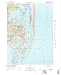
1974 Map of Chatham
USGS Topo · Published 1978About this map
Chatham and the surrounding coastline of Pleasant Bay are defined by an intricate network of tidal flats and coastal ponds in this mid-1970s landscape. The settlement patterns of North Chatham, Chatham Port, and West Chatham are well-established, showing the transition from traditional maritime hubs to coastal residences. On Nickersons Neck, the Eastward Ho Country Club and Chatham Yacht Club represent the era's recreational development, while the Chatham Lighthouse and multiple radio towers, including Radio Tower (WOCB), reflect the town's ongoing role in navigation and communication.
Find a feature on this map
85 named features on this map. Tap any name to fly to it.
Don’t see what you’re looking for? This feature index may not catch every label — zoom into the map to look around manually.
Map Details
Editions of this 1974 Chatham Map
4 editions found
Other maps of this area

1887 · Wellfleet
USGS Topo · 1:62,500

1887 · Yarmouth
USGS Topo · 1:62,500

1888 · Chatham
USGS Topo · 1:62,500

1889 · Yarmouth
USGS Topo · 1:62,500

1889 · Wellfleet
USGS Topo · 1:62,500

1893 · Chatham
USGS Topo · 1:62,500

1893 · Yarmouth
USGS Topo · 1:62,500

1893 · Wellfleet
USGS Topo · 1:62,500

1917 · Chatham
USGS Topo · 1:62,500

1942 · Cape Cod Bay
USGS Topo · 1:125,000