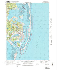
1974 Map of Chatham
USGS Topo · Published 1978About this map
Chatham and its intricate coastal landscape are documented here during the mid-1970s, reflecting a period of established maritime heritage and conservation. The map highlights the town's complex interface with the Atlantic, featuring the Chatham Lighthouse standing watch over Chatham Roads and the entrance to Stage Harbor. The terrestrial landscape is defined by family-named landmarks like Nickersons Neck and Cedar Neck, while the interior is pockmarked with glacial kettle ponds such as Lovers Lake and Stillwater Pond.
Find a feature on this map
79 named features on this map. Tap any name to fly to it.
Don’t see what you’re looking for? This feature index may not catch every label — zoom into the map to look around manually.
Map Details
Editions of this 1974 Chatham Map
4 editions found
Other maps of this area

1887 · Wellfleet
USGS Topo · 1:62,500

1887 · Yarmouth
USGS Topo · 1:62,500

1888 · Chatham
USGS Topo · 1:62,500

1889 · Yarmouth
USGS Topo · 1:62,500

1889 · Wellfleet
USGS Topo · 1:62,500

1893 · Chatham
USGS Topo · 1:62,500

1893 · Yarmouth
USGS Topo · 1:62,500

1893 · Wellfleet
USGS Topo · 1:62,500

1917 · Chatham
USGS Topo · 1:62,500

1942 · Cape Cod Bay
USGS Topo · 1:125,000