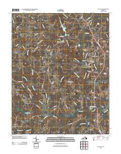
2011 Map of Chatham
USGS Topo · Published 2011About this map
The Banister River meanders through the southern half of this landscape, anchoring a rural Virginia region characterized by small communities and water management. The town of Chatham serves as the central hub, surrounded by residential developments like Whittletown, Beverly Heights, and Woodlawn Heights. Local infrastructure is notably defined by several dams, including Cherrystone Number One Dam and Cherrystone Number 2a Dam, which regulate the flow of Cherrystone Creek as it feeds into Falls Lake.
Find a feature on this map
81 named features on this map. Tap any name to fly to it.
Don’t see what you’re looking for? This feature index may not catch every label — zoom into the map to look around manually.
Map Details
Editions of this 2011 Chatham Map
This is the sole edition of this map. No revisions or reprints were ever made.
Other maps of this area

1921 · Chatham
USGS Topo · 1:48,000

1922 · Callands
USGS Topo · 1:48,000

1923 · Danville
USGS Topo · 1:48,000

1923 · Chatham
USGS Topo · 1:62,500

1924 · Draper
USGS Topo · 1:48,000

1924 · Callands
USGS Topo · 1:62,500

1925 · Danville
USGS Topo · 1:62,500

1926 · Draper
USGS Topo · 1:62,500

1944 · Draper
USGS Topo · 1:62,500

1944 · Callands
USGS Topo · 1:62,500