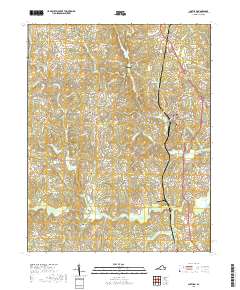
2019 Map of Chatham
USGS Topo · Published 2019About this map
The Pittsylvania County Courthouse stands as the civic heart of this Virginia Piedmont landscape, where the town of Chatham serves as a central hub for the surrounding rural communities. This modern survey illustrates a topography defined by an intricate network of watercourses, with the Banister River winding through the southern portion of the quadrangle. Significant water bodies like Cherrystone Lake and Falls Lake are prominent, suggesting a landscape managed for local reservoirs and recreation.
Find a feature on this map
121 named features on this map. Tap any name to fly to it.
Don’t see what you’re looking for? This feature index may not catch every label — zoom into the map to look around manually.
Map Details
Editions of this 2019 Chatham Map
This is the sole edition of this map. No revisions or reprints were ever made.
Other maps of this area

1921 · Chatham
USGS Topo · 1:48,000

1922 · Callands
USGS Topo · 1:48,000

1923 · Danville
USGS Topo · 1:48,000

1923 · Chatham
USGS Topo · 1:62,500

1924 · Draper
USGS Topo · 1:48,000

1924 · Callands
USGS Topo · 1:62,500

1925 · Danville
USGS Topo · 1:62,500

1926 · Draper
USGS Topo · 1:62,500

1944 · Draper
USGS Topo · 1:62,500

1944 · Callands
USGS Topo · 1:62,500