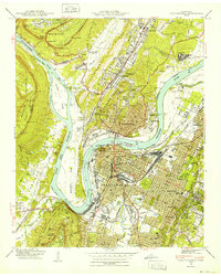
1940 Map of Chattanooga
USGS Topo · Published 1940About this map
Chattanooga serves as the focal point of this 1940 Tennessee Valley Authority and USGS collaboration, capturing the city just as its industrial and transport infrastructure reached a pre-war peak. The heavy rail network of the Southern and NC & St L converges at massive hubs like Union Station and Terminal Station, while the Tennessee River loops around the iconic Moccasin Bend. This survey documents a landscape of deep historical memory, including the National Cem and Confederate Cem, alongside the residential growth of neighborhoods like North Chattanooga and Highland Park.
Find a feature on this map
114 named features on this map. Tap any name to fly to it.
Don’t see what you’re looking for? This feature index may not catch every label — zoom into the map to look around manually.
Map Details
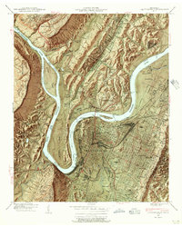
Editions of this 1940 Chattanooga Map
2 editions found
Other maps of this area

1886 · Ringgold
USGS Topo · 1:125,000

1888 · Chattanooga
USGS Topo · 1:125,000

1892 · Ringgold
USGS Topo · 1:125,000

1893 · Chattanooga
USGS Topo · 1:125,000

1935 · East Chattanooga
USGS Topo · 1:24,000

1935 · Daisy
USGS Topo · 1:24,000

1935 · East Ridge
USGS Topo · 1:24,000

1936 · Ketner Gap
USGS Topo · 1:24,000

1936 · Hooker
USGS Topo · 1:24,000

1936 · Fort Oglethorpe
USGS Topo · 1:24,000