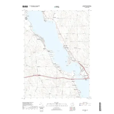
2019 Map of Chautauqua
USGS Topo · Published 2019About this map
Chautauqua Lake anchors this geographic study of Chautauqua County, New York, revealing a dense network of lakeside communities and historic cemeteries. The western shore is defined by the Chautauqua institution and its gridded street plan, featuring Pratt Ave and Massey Ave, while the eastern shore centers on the bustling Bemus Point narrows. This 2019 survey documents the enduring layout of vacation colonies and permanent settlements like Mayville and Maple Springs. Genealogy and local history are well-represented by numerous burial sites, including Dewittville Cem, Prendergast Cem, and the Wild Rose Cem. The landscape transition from the water's edge at Sunset Bay and Long Point to the upland farming and residential areas near Stedman illustrates the region's dual identity as both a resort destination and a rural New York community.
Find a feature on this map
121 named features on this map. Tap any name to fly to it.
Don’t see what you’re looking for? This feature index may not catch every label — zoom into the map to look around manually.
Map Details
Editions of this 2019 Chautauqua Map
This is the sole edition of this map. No revisions or reprints were ever made.
Other maps of this area

1899 · Westfield
USGS Topo · 1:62,500

1900 · Dunkirk
USGS Topo · 1:62,500

1904 · Chautaqua
USGS Topo · 1:62,500

1905 · Clymer
USGS Topo · 1:62,500

1939 · Clymer
USGS Topo · 1:62,500

1941 · Chautauqua
USGS Topo · 1:62,500

1941 · Clymer
USGS Topo · 1:62,500

1943 · Dunkirk
USGS Topo · 1:62,500

1954 · Chautauqua
USGS Topo · 1:24,000

1954 · Ellery Center
USGS Topo · 1:24,000