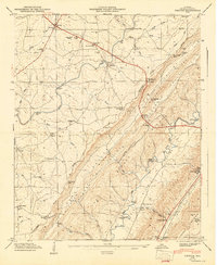
1947 Map of Chavies
USGS Topo · Published 1947About this map
Sand Mountain and the deep cleft of Big Wills Valley dominate this 1940s landscape, illustrating the rugged topography of DeKalb County. The plateau of Sand Mountain is dotted with rural settlements like Rainsville, Chavies, and Lydia, connected by a network of roads and trails that navigate the steep descents through numerous gaps. Several creek crossings rely on historic points such as Suttell Ford and Bohannon Ford, while industrial footprints are visible at Hughes Mill and Killian Mill. The survey reflects a deeply rooted community, documented through numerous country churches like Mt Moriah Ch and schools including the Log Cabin Sch. At the southeastern edge, the terrain rises again toward Lookout Mountain, with the valley floor supporting the Southern Railway corridor and critical infrastructure like the Fort Payne Water Works.
Find a feature on this map
67 named features on this map. Tap any name to fly to it.
Don’t see what you’re looking for? This feature index may not catch every label — zoom into the map to look around manually.
Map Details
Editions of this 1947 Chavies Map
This is the sole edition of this map. No revisions or reprints were ever made.
Other maps of this area

1886 · Stevenson
USGS Topo · 1:125,000

1892 · Stevenson
USGS Topo · 1:125,000

1893 · Fort Payne
USGS Topo · 1:125,000

1895 · Stevenson
USGS Topo · 1:125,000

1898 · Fort Payne
USGS Topo · 1:125,000

1900 · Fort Payne
USGS Topo · 1:125,000

1936 · Crossville
USGS Topo · 1:24,000

1936 · Dugout Valley
USGS Topo · 1:24,000

1936 · Chavies
USGS Topo · 1:24,000

1936 · Dutton
USGS Topo · 1:24,000