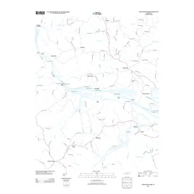
2013 Map of Cheatham Dam
USGS Topo · Published 2013About this map
Cumberland River navigation and the engineering of Cheatham Dam define the central corridor of this Tennessee landscape in the early 21st century. The map illustrates a dense network of water-access points such as Betsystown Landing, Stones Landing, and Fambroughs Landing, reflecting the area's continued reliance on the river for transport and recreation. To the south, the confluence of the Harpeth River near Pack Island meets the larger waterway, crossed by the Montgomery Bell Bridge. The upland areas are characterized by small, established communities like Cheap Hill, Bellsburg, and Chapmansboro, often clustered around historic roads and rural landmarks like Jackson Chapel. This documentation of the river valley captures the complex hydrology of the region, including Harpeth Shoals and numerous tributaries like Half Pone Cr and Sycamore Cr.
Find a feature on this map
140 named features on this map. Tap any name to fly to it.
Don’t see what you’re looking for? This feature index may not catch every label — zoom into the map to look around manually.
Map Details
Editions of this 2013 Cheatham Dam Map
This is the sole edition of this map. No revisions or reprints were ever made.
Other maps of this area

1930 · White Bluff
USGS Topo · 1:62,500

1933 · White Bluff
USGS Topo · 1:62,500

1956 · Nashville
USGS Topo · 1:250,000

1957 · Cheatham Dam
USGS Topo · 1:24,000

1957 · Pleasant View
USGS Topo · 1:24,000

1957 · Henrietta
USGS Topo · 1:24,000

1957 · Ashland City
USGS Topo · 1:24,000

1958 · Charlotte
USGS Topo · 1:24,000

1958 · Cumberland Furnace
USGS Topo · 1:24,000
1958 · Excell
USGS Topo · 1:24,000