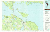
1984 Map of Cheboygan
USGS Topo · Published 1985About this map
The St Ignace and Mackinaw City area is defined by the convergence of Lake Michigan and Lake Huron at the Straits of Mackinac. This 1980s-era planimetric study highlights the extensive public lands throughout the region, from the Hiawatha National Forest on the Upper Peninsula to the Mackinaw State Forest on the Lower. Strategic transit hubs like the Cheboygan City-County Airport and the Mackinac Island Airport serve the scattered island communities and mainland settlements. Inland, the map reveals a landscape of large lakes such as Brevoort Lake and Burt Lake, surrounded by small rural junctions like Riggsville, Levering, and Pellston. The presence of numerous designated conservation areas, including Wilderness State Park and Bois Blanc State Forest, underscores the preserved natural character of the northern Michigan shoreline during this period.
Find a feature on this map
190 named features on this map. Tap any name to fly to it.
Don’t see what you’re looking for? This feature index may not catch every label — zoom into the map to look around manually.
Map Details
Editions of this 1984 Cheboygan Map
This is the sole edition of this map. No revisions or reprints were ever made.
Other maps of this area

1931 · St Ignace NW
USGS Topo · 1:31,680

1931 · Pickford SE
USGS Topo · 1:31,680

1931 · Epoufette SE
USGS Topo · 1:31,680

1931 · Moran NE
USGS Topo · 1:31,680

1931 · Ozark SE
USGS Topo · 1:31,680

1932 · St Ignace NE
USGS Topo · 1:31,680

1948 · Moran NE
USGS Topo · 1:31,680

1948 · Moran NW
USGS Topo · 1:31,680

1954 · Alpena
USGS Topo · 1:250,000

1954 · Sault Sainte Marie
USGS Topo · 1:250,000