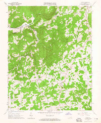
1963 Map of Check
USGS Topo · Published 1965About this map
South Fork Roanoke River drainage patterns define this highland landscape in the mid-1960s, where the rural communities of Check and Copper Hill serve as local hubs. This survey is particularly valuable for its meticulous documentation of property boundaries, featuring fine red dashed lines that indicate fence and field lines visible from 1962 aerial photography. The settlement pattern is largely dictated by the complex network of creeks like Goose Creek and Sugar Run, with small centers of activity such as Simpsons and Piedmont situated at key valley junctions. Local social life is evidenced by numerous rural institutions, including Hemlock School, the Drive-in Theater near Meadow Creek, and several family-named burial grounds like Simpson Cemetery and Poff Cemetery. The Blue Ridge Parkway skirts the eastern edge of the quadrangle, marking the transition from agricultural valley floors to the higher elevations of the Blue Ridge mountains.
Find a feature on this map
42 named features on this map. Tap any name to fly to it.
Don’t see what you’re looking for? This feature index may not catch every label — zoom into the map to look around manually.
Map Details
Editions of this 1963 Check Map
3 editions found
Other maps of this area

1890 · Christiansburg
USGS Topo · 1:125,000

1932 · Blacksburg
USGS Topo · 1:48,000

1937 · Blacksburg
USGS Topo · 1:62,500

1950 · Elliston
USGS Topo · 1:62,500

1953 · Winston-Salem
USGS Topo · 1:250,000

1955 · Bluefield
USGS Topo · 1:250,000

1955 · Winston-Salem
USGS Topo · 1:250,000

1957 · Endicott
USGS Topo · 1:62,500

1957 · Floyd
USGS Topo · 1:62,500

1957 · Bluefield
USGS Topo · 1:250,000