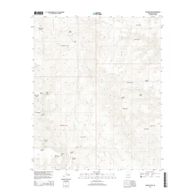
2014 Map of Chediski Peak
USGS Topo · Published 2014About this map
Chediski Peak and the surrounding high ridges of Navajo County define this topographic study, where steep canyons and volcanic features dominate the landscape of the Fort Apache Indian Reservation. The map documents a complex network of drainages including Cibecue Cr and Canyon Cr, which carve through varied elevations marked by distinctive landmarks like The Pyramids and Chediski Mtn. Evidence of historic and modern land use appears in the naming of cattle-related sites such as Cow Flat, Steer Ridge, and Lost Tank Canyon. The presence of Bureau of Indian Affairs routes, such as Bia-34, indicates the essential infrastructure connecting this high-country terrain. Natural water sources like Rotten Spring, Nyce Lake, and Chuck Box Lake provide vital points of interest in an otherwise arid, high-elevation environment.
Find a feature on this map
41 named features on this map. Tap any name to fly to it.
Don’t see what you’re looking for? This feature index may not catch every label — zoom into the map to look around manually.
Map Details
Editions of this 2014 Chediski Peak Map
This is the sole edition of this map. No revisions or reprints were ever made.
Other maps of this area

1886 · Holbrook
USGS Topo · 1:250,000

1893 · Holbrook
USGS Topo · 1:250,000

1954 · Holbrook
USGS Topo · 1:250,000

1957 · Holbrook
USGS Topo · 1:250,000

1958 · Holbrook
USGS Topo · 1:250,000

1960 · Holbrook
USGS Topo · 1:250,000

1961 · Woods Canyon
USGS Topo · 1:62,500

1961 · Heber
USGS Topo · 1:62,500

1961 · Chediski Peak
USGS Topo · 1:62,500
1961 · Young
USGS Topo · 1:62,500