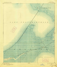
1892 Map of Chef Menteur
USGS Topo · Published 1914About this map
Ft Macomb stands as a primary landmark in this late 19th-century coastal survey, guarding the critical waterway of Chef Menteur Pass. The landscape is dominated by the complex marshlands of the Trembling Prairie, where the transition from Lake Pontchartrain to Lake Borgne is navigated by a network of waterways including Bayou Sauvage and Cedar Bayou.
Find a feature on this map
18 named features on this map. Tap any name to fly to it.
Don’t see what you’re looking for? This feature index may not catch every label — zoom into the map to look around manually.
Map Details
Editions of this 1892 Chef Menteur Map
5 editions found
Other maps of this area

1891 · Spanish Fort
USGS Topo · 1:62,500

1891 · New Orleans
USGS Topo · 1:62,500

1892 · Chef Menteur
USGS Topo · 1:62,500

1892 · St. Bernard
USGS Topo · 1:62,500

1893 · Rigolets
USGS Topo · 1:62,500

1893 · Shell Beach
USGS Topo · 1:62,500

1914 · Nicholson
USGS Topo · 1:62,500

1921 · Nicholson
USGS Topo · 1:62,500

1932 · New Orleans NE
USGS Topo · 1:31,680

1935 · Slidell
USGS Topo · 1:62,500