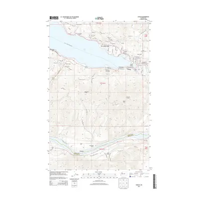
2014 Map of Chelan
USGS Topo · Published 2014About this map
Lake Chelan serves as the focal point for this region, where the town of Chelan sits at its eastern tip where the Chelan River begins its short descent. The landscape is defined by the sharp transition from the water to high surrounding terrain, including the prominent Chelan Butte and deep incisions like Purtteman Gulch and Knapp Coulee. Transportation and recreation are central to the area's identity, evidenced by the Chelan - Lucerne Ferry Crossing and the Lady-of-the-Lake Commercial Dock. Along the southern border, the Columbia River carves a separate path near Stayman and Dover Flat. This map captures a developed lakefront economy with established neighborhoods like Lakeside and Lake Chelan Hills, and the Chelan Fraternal Cem providing a site for genealogical research near Cagle Gulch.
Find a feature on this map
81 named features on this map. Tap any name to fly to it.
Don’t see what you’re looking for? This feature index may not catch every label — zoom into the map to look around manually.
Map Details
Editions of this 2014 Chelan Map
This is the sole edition of this map. No revisions or reprints were ever made.
Other maps of this area

1901 · Chelan
USGS Topo · 1:125,000

1953 · Ritzville
USGS Topo · 1:250,000

1957 · Wenatchee
USGS Topo · 1:250,000

1959 · Ritzville
USGS Topo · 1:250,000

1965 · Ritzville
USGS Topo · 1:250,000

1968 · Chelan
USGS Topo · 1:24,000

1968 · Lamoine
USGS Topo · 1:24,000

1968 · Chelan Falls
USGS Topo · 1:24,000
1968 · Azwell
USGS Topo · 1:24,000

1968 · Waterville
USGS Topo · 1:24,000