
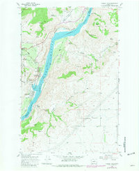
1968 Map of Chelan Falls
USGS Topo · Published 1971About this map
The Columbia River forms a dramatic boundary between Chelan and Douglas counties, where the high desert plateau of Howard Flats drops away toward the water. This 1968 survey captures a landscape defined by the impoundment of Lake Entiat and the industrial activity near Chelan Falls. The presence of the Burlington Northern railroad line, winding along the western shore through Chelan Station, highlights the region's transport history, connecting remote settlements like Beebe to the broader regional economy. Land use on the map is remarkably varied, showing the Chelan Municipal Airport on the northern flats and the Chelan State Fish Hatchery near the riverbank. Genealogists and local historians can locate the Riverview Cem overlooking the river, while the numerous named water sources like Beebe Spring and Jackson Spring point to the critical importance of water rights in this arid orchard-growing region.
Find a feature on this map
37 named features on this map. Tap any name to fly to it.
Don’t see what you’re looking for? This feature index may not catch every label — zoom into the map to look around manually.
Map Details
Editions of this 1968 Chelan Falls Map
2 editions found
Other maps of this area

1901 · Chelan
USGS Topo · 1:125,000

1953 · Ritzville
USGS Topo · 1:250,000

1957 · Wenatchee
USGS Topo · 1:250,000

1959 · Ritzville
USGS Topo · 1:250,000

1965 · Ritzville
USGS Topo · 1:250,000

1968 · Withrow
USGS Topo · 1:24,000

1968 · Chelan
USGS Topo · 1:24,000

1968 · Lamoine
USGS Topo · 1:24,000

1968 · Wells Dam
USGS Topo · 1:24,000
1968 · Azwell
USGS Topo · 1:24,000