
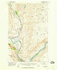
1968 Map of Wells Dam
USGS Topo · Published 1971About this map
Wells Dam dominates the mid-Columbia landscape on this late-1960s survey, marking a significant era of hydroelectric development and water management at the junction of Douglas, Chelan, and Okanogan counties. The impounded waters of Columbia River Lake Pateros are shown alongside essential infrastructure like the Powerhouse and Fish Hatchery. Beyond the riverbanks, the map documents a transition from industrial utility to a landscape of isolated springs and dry upland draws.
Find a feature on this map
37 named features on this map. Tap any name to fly to it.
Don’t see what you’re looking for? This feature index may not catch every label — zoom into the map to look around manually.
Map Details
Editions of this 1968 Wells Dam Map
2 editions found

Other maps of this area

1905 · Okanogan
USGS Topo · 1:125,000

1953 · Ritzville
USGS Topo · 1:250,000

1954 · Okanogan
USGS Topo · 1:250,000
1957 · Bridgeport
USGS Topo · 1:62,500
1957 · Brewster
USGS Topo · 1:62,500

1958 · Okanogan
USGS Topo · 1:250,000

1959 · Ritzville
USGS Topo · 1:250,000

1965 · Ritzville
USGS Topo · 1:250,000
1968 · Chelan Falls
USGS Topo · 1:24,000

1968 · Chief Joseph Dam
USGS Topo · 1:24,000