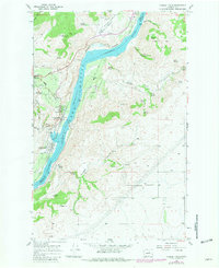
1968 Map of Chelan Falls
USGS Topo · Published 1981About this map
The Columbia River and Lake Entia T form a powerful central corridor through this landscape at the junction of the Chelan and Douglas County line. The steep canyon walls are punctuated by numerous family-named water sources and landmarks, including McNeil Canyon, Buckner Spring, and Griffin Spring. Settlement is concentrated at the riverside junctions of Chelan Falls and Chelan Station, where industrial development is marked by a Powerplant and the Burlington Northern railroad line that tracks the riverbank. This 1981 photorevision reveals the infrastructure of the mid-20th-century Columbia Basin, from the Chelan State Fish Hatchery to the orchards and Howard Flats plateau. Local heritage is preserved in sites like Riverview Cem and the small riverside community of Beebe, showing the area's transition from early pioneer outposts to a modernized agricultural and energy-producing hub.
Find a feature on this map
42 named features on this map. Tap any name to fly to it.
Don’t see what you’re looking for? This feature index may not catch every label — zoom into the map to look around manually.
Map Details
Editions of this 1968 Chelan Falls Map
2 editions found
Other maps of this area

1901 · Chelan
USGS Topo · 1:125,000

1953 · Ritzville
USGS Topo · 1:250,000

1957 · Wenatchee
USGS Topo · 1:250,000

1959 · Ritzville
USGS Topo · 1:250,000

1965 · Ritzville
USGS Topo · 1:250,000

1968 · Withrow
USGS Topo · 1:24,000

1968 · Chelan
USGS Topo · 1:24,000

1968 · Lamoine
USGS Topo · 1:24,000

1968 · Chelan Falls
USGS Topo · 1:24,000

1968 · Wells Dam
USGS Topo · 1:24,000