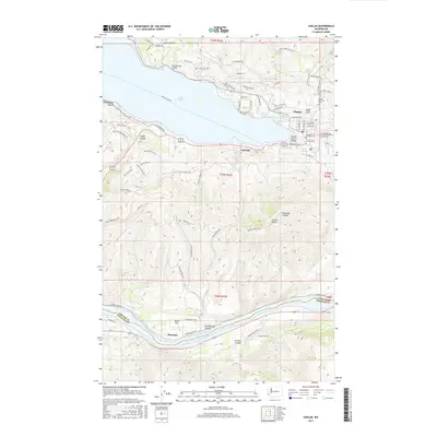
2017 Map of Chelan
USGS Topo · Published 2017About this map
Lake Chelan dominates the landscape as it funnels into the Chelan River, where the community of Chelan and the adjoining settlement of Lakeside serve as the focal point of the region. The map reveals a land defined by dramatic transitions, from the residential clusters and orchards near Minneapolis Beach and Purtteman Gulch to the steep elevations of Chelan Butte. This 2017 survey details the complex road network serving the high-elevation benches and coulees, including Knapp Coulee and Daybreak Canyon. Along the southern reach of the sheet, the Columbia River flows through Lake Entiat, past the small settlements of Stayman and Dover Flat. This geography illustrates the historical importance of the river systems for both irrigation and transit, with the Woodin Avenue Bridge providing a critical link across the water at the head of the river gorge.
Find a feature on this map
83 named features on this map. Tap any name to fly to it.
Don’t see what you’re looking for? This feature index may not catch every label — zoom into the map to look around manually.
Map Details
Editions of this 2017 Chelan Map
This is the sole edition of this map. No revisions or reprints were ever made.
Other maps of this area

1901 · Chelan
USGS Topo · 1:125,000

1953 · Ritzville
USGS Topo · 1:250,000

1957 · Wenatchee
USGS Topo · 1:250,000

1959 · Ritzville
USGS Topo · 1:250,000

1965 · Ritzville
USGS Topo · 1:250,000

1968 · Chelan
USGS Topo · 1:24,000

1968 · Lamoine
USGS Topo · 1:24,000

1968 · Chelan Falls
USGS Topo · 1:24,000
1968 · Azwell
USGS Topo · 1:24,000

1968 · Waterville
USGS Topo · 1:24,000