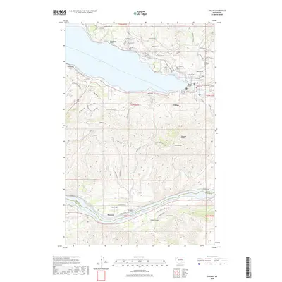
2020 Map of Chelan
USGS Topo · Published 2020About this map
Lake Chelan dominates this 2020 landscape, providing a deep glacial backdrop to the developed shoreline of Chelan and Lakeside. The terrain transitions sharply from the waterfront to the high ground of Chelan Butte, while the southern portion of the map follows the Columbia River at Lake Entiat. This survey shows a mix of recreational development at Minneapolis Beach and agricultural infrastructure along the lower river near Stayman and Dover Flat. Genealogists and local historians can locate the Chelan Fraternal Cem and the central Post Office within the town grid. The complex topography is marked by significant drainages such as Purtteman Gulch, Knapp Coulee, and Cagle Gulch, which shaped the early paths of Wapato Butte Rd and Union Valley Rd. The map also documents the Chelan Co Douglas Co boundary as it cuts across the southern hills.
Find a feature on this map
85 named features on this map. Tap any name to fly to it.
Don’t see what you’re looking for? This feature index may not catch every label — zoom into the map to look around manually.
Map Details
Editions of this 2020 Chelan Map
This is the sole edition of this map. No revisions or reprints were ever made.
Other maps of this area

1901 · Chelan
USGS Topo · 1:125,000

1953 · Ritzville
USGS Topo · 1:250,000

1957 · Wenatchee
USGS Topo · 1:250,000

1959 · Ritzville
USGS Topo · 1:250,000

1965 · Ritzville
USGS Topo · 1:250,000

1968 · Chelan
USGS Topo · 1:24,000

1968 · Lamoine
USGS Topo · 1:24,000

1968 · Chelan Falls
USGS Topo · 1:24,000
1968 · Azwell
USGS Topo · 1:24,000

1968 · Waterville
USGS Topo · 1:24,000