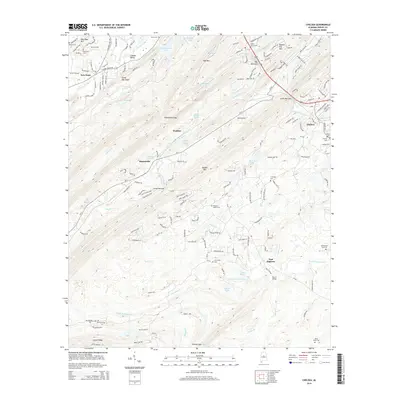
2014 Map of Chelsea
USGS Topo · Published 2014About this map
Chelsea and the surrounding Shelby County foothills are defined by the parallel ridges of Oak Mtn and Double Oak Mtn, which frame the residential and agricultural corridors of the Cahaba Valley. This modern survey documents the suburban expansion of communities like New Hope and Simmsville as they grow into the gaps between these steep elevations. Historical depth is found in the distribution of family-named burial grounds such as Bailey Cem, Old Anton Cem, and the Mose Davis Cem near East Saginaw, pointing to generations of rural settlement before recent development. The landscape is dotted with small private impoundments including Lake Gizella, Demopolis Lake, and Bowden Lake, which serve as focal points for local land tracts. Critical passage points like Shackleford Gap and Morris Bridge illustrate how the geography of ridges and the S Fork Yellowleaf Cr have dictated the local transit network.
Find a feature on this map
175 named features on this map. Tap any name to fly to it.
Don’t see what you’re looking for? This feature index may not catch every label — zoom into the map to look around manually.
Map Details
Editions of this 2014 Chelsea Map
This is the sole edition of this map. No revisions or reprints were ever made.
Other maps of this area

1890 · Bessemer
USGS Topo · 1:125,000

1892 · Bessemer
USGS Topo · 1:125,000

1905 · Bessemer Iron District
USGS Topo · 1:62,500

1906 · Vandiver
USGS Topo · 1:62,500

1907 · Bessemer Special
USGS Topo · 1:62,500

1908 · Vandiver
USGS Topo · 1:62,500

1909 · Columbiana
USGS Topo · 1:62,500

1910 · Montevallo
USGS Topo · 1:62,500

1911 · Columbiana
USGS Topo · 1:62,500

1953 · Birmingham
USGS Topo · 1:250,000