
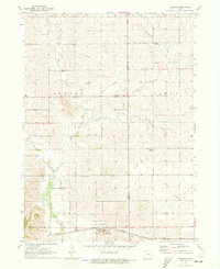
1968 Map of Chelsea
USGS Topo · Published 1970About this map
The Iowa River snakes through the heart of this Tama County landscape, creating a broad alluvial valley defined by complex wetlands and drainage patterns. Dominating the central terrain is the Otter Creek Marsh State Wildlife Refuge, a significant conservation area where the Otter Creek meets the river's flood plain. The town of Chelsea serves as a local hub at the intersection of the Chicago and North Western rail line and the river, while smaller settlements like Vining, Gladstone, and Helena mark the surrounding agricultural uplands. Genealogy researchers will find a high density of family-named and organizational burial sites, including IOOF Cem, St Josephs Cem, and Wilkinson Cem. The map also documents industrial and infrastructure details of the late 1960s, such as the Plague Mine, a Gaging Station on the river, and a Radio Facility near the southern boundary.
Find a feature on this map
30 named features on this map. Tap any name to fly to it.
Don’t see what you’re looking for? This feature index may not catch every label — zoom into the map to look around manually.
Map Details
Editions of this 1968 Chelsea Map
This is the sole edition of this map. No revisions or reprints were ever made.
Other maps of this area

1954 · Waterloo
USGS Topo · 1:250,000

1954 · Des Moines
USGS Topo · 1:250,000

1955 · Waterloo
USGS Topo · 1:250,000

1956 · Des Moines
USGS Topo · 1:250,000

1957 · Des Moines
USGS Topo · 1:250,000

1968 · Belle Plaine SW
USGS Topo · 1:24,000

1968 · Belle Plaine
USGS Topo · 1:24,000

1968 · Hartwick
USGS Topo · 1:24,000

1969 · Des Moines
USGS Topo · 1:250,000
1971 · Elberon
USGS Topo · 1:24,000