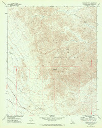
1971 Map of Chemehuevi Peak
USGS Topo · Published 1973About this map
Chemehuevi Peak rises as the central landmark within this portion of the Chemehuevi Mountains, dominating a landscape defined by sharp elevation shifts and dry drainage systems. This 1971 survey captures the area before modern expansion, showing a network of Jeep Trails and the Havasu Lake Road cutting through the Chemehuevi Valley. The presence of a Prospect near the Sawtooth Range points to the region's mineral exploration history, while isolated water sources like Studio Spring and a generic Spring highlight the critical, sparse hydrology of the high desert. To the north, the broad Trampas Wash carves through the terrain, illustrating the natural erosion patterns that have shaped these mountains over time.
Find a feature on this map
15 named features on this map. Tap any name to fly to it.
Don’t see what you’re looking for? This feature index may not catch every label — zoom into the map to look around manually.
Map Details
Editions of this 1971 Chemehuevi Peak Map
This is the sole edition of this map. No revisions or reprints were ever made.
Other maps of this area

1903 · Needles
USGS Topo · 1:125,000

1904 · Needles Special
USGS Topo · 1:125,000

1911 · Parker
USGS Topo · 1:125,000

1943 · Topock
USGS Topo · 1:62,500

1943 · Whipple Mts.
USGS Topo · 1:62,500

1950 · Topock
USGS Topo · 1:62,500

1950 · Sawtooth Range
USGS Topo · 1:62,500

1950 · Whipple Mts
USGS Topo · 1:62,500

1950 · Savahia Peak
USGS Topo · 1:62,500

1951 · Topock
USGS Topo · 1:62,500