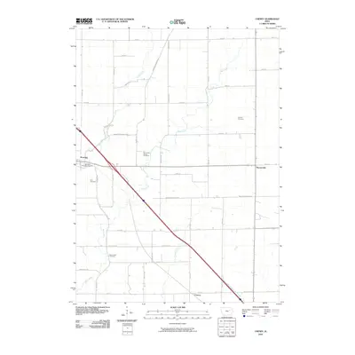
2010 Map of Cheney
USGS Topo · Published 2010About this map
Brandon sits at the western edge of this landscape, where the local road network converges near the banks of Bear Creek. The terrain is defined by a series of waterways, including Lime Creek, Prairie Creek, and the West Branch Blue Creek, which carve through the agricultural grid. A strong emphasis on local genealogy is evident through the numerous burial sites across the quadrangle, such as the Jefferson Township Cemetery and the Bear Creek School Cemetery. The settlement pattern follows a distinct diagonal axis along Brandon Diagonal Blvd, contrasting with the rigid north-south and east-west alignments of routes like Harrison Ave and Iowa Ave. Small hamlets like Hamerville and Cheney anchor the eastern and southern portions of the map, serving as localized nodes in this rural Buchanan County environment.
Find a feature on this map
41 named features on this map. Tap any name to fly to it.
Don’t see what you’re looking for? This feature index may not catch every label — zoom into the map to look around manually.
Map Details
Editions of this 2010 Cheney Map
This is the sole edition of this map. No revisions or reprints were ever made.
Other maps of this area

1888 · Shellsburg
USGS Topo · 1:62,500

1889 · Shellsburg
USGS Topo · 1:62,500

1899 · Shellsburg
USGS Topo · 1:62,500

1903 · Winthrop
USGS Topo · 1:125,000

1954 · Waterloo
USGS Topo · 1:250,000

1955 · Waterloo
USGS Topo · 1:250,000

1959 · Dubuque
USGS Topo · 1:250,000

1961 · Dubuque
USGS Topo · 1:250,000

1962 · Dubuque
USGS Topo · 1:250,000
1968 · Center Point
USGS Topo · 1:24,000