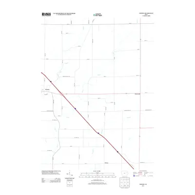
2013 Map of Cheney
USGS Topo · Published 2013About this map
Brandon occupies the western edge of this agricultural landscape in Buchanan County, where the road network follows a rigid section-line grid typical of the Midwest. The settlement of Cheney sits toward the southeast, while Hamerville serves as a small crossroad junction to the east. The terrain is defined by the gentle drainage patterns of Bear Cr and Prairie Cr, which meander through fields and pastures between established homesteads. The diagonal path of Brandon Diagonal Blvd breaks the township's geometric regularity, tracing a historic transit corridor toward the heart of the community. Genealogists and local historians can use this survey to map out family farmsteads and rural property locations along thoroughfares like Benton Buchanan Rd and 50th Street Dr during the early 21st century.
Find a feature on this map
43 named features on this map. Tap any name to fly to it.
Don’t see what you’re looking for? This feature index may not catch every label — zoom into the map to look around manually.
Map Details
Editions of this 2013 Cheney Map
This is the sole edition of this map. No revisions or reprints were ever made.
Other maps of this area

1888 · Shellsburg
USGS Topo · 1:62,500

1889 · Shellsburg
USGS Topo · 1:62,500

1899 · Shellsburg
USGS Topo · 1:62,500

1903 · Winthrop
USGS Topo · 1:125,000

1954 · Waterloo
USGS Topo · 1:250,000

1955 · Waterloo
USGS Topo · 1:250,000

1959 · Dubuque
USGS Topo · 1:250,000

1961 · Dubuque
USGS Topo · 1:250,000

1962 · Dubuque
USGS Topo · 1:250,000
1968 · Center Point
USGS Topo · 1:24,000