1973 Map of Cheney
USGS Topo · Published 1977About this map
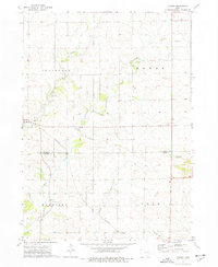
Lime Creek and Bear Creek wind through this agricultural landscape at the border of Buchanan and Benton Counties during the early 1970s. The settlement of Brandon sits on the western edge of the quadrangle, serving as a local hub near Township Cemetery and several limestone quarries. The map captures a rural Iowa landscape defined by organized townships including Jefferson, Homer, Harrison, and Polk. Local governance and community life are anchored by the Townhall and the quiet hamlet of Cheney in the southern portion of the sheet.
Find a feature on this map
21 named features on this map. Tap any name to fly to it.
Don’t see what you’re looking for? This feature index may not catch every label — zoom into the map to look around manually.
Map Details
Editions of this 1973 Cheney Map
This is the sole edition of this map. No revisions or reprints were ever made.
Other maps of this area

1888 · Shellsburg
USGS Topo · 1:62,500

1889 · Shellsburg
USGS Topo · 1:62,500

1899 · Shellsburg
USGS Topo · 1:62,500

1903 · Winthrop
USGS Topo · 1:125,000

1954 · Waterloo
USGS Topo · 1:250,000

1955 · Waterloo
USGS Topo · 1:250,000

1959 · Dubuque
USGS Topo · 1:250,000

1961 · Dubuque
USGS Topo · 1:250,000

1962 · Dubuque
USGS Topo · 1:250,000
1968 · Center Point
USGS Topo · 1:24,000