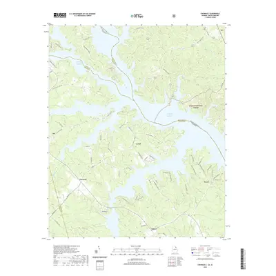
2020 Map of Chennault
USGS Topo · Published 2020About this map
The J. Strom Thurmond Reservoir dominates this landscape where the Savannah River valley meets the Georgia-South Carolina border. In this modern era, the expansive reservoir has reshaped the local geography, yet old inland settlements and rural road networks persist. Historically significant nodes like Chennault and Graball remain as markers of the area's agricultural and social foundations. To the east, the Sumter National Forest preserves the wooded character of the McCormick County side of the water, while the Georgia banks in Lincoln and Wilkes Counties show a mix of residential developments like Fishing Creek Ests and traditional rural routes. Longstanding transportation corridors such as Mallorysville Lisbon Rd and the memory of old river crossings at Hester S Ferry Rd provide essential context for researchers tracing the evolution of these riverfront communities from early landings to contemporary lakeside locales.
Find a feature on this map
68 named features on this map. Tap any name to fly to it.
Don’t see what you’re looking for? This feature index may not catch every label — zoom into the map to look around manually.
Map Details
Editions of this 2020 Chennault Map
This is the sole edition of this map. No revisions or reprints were ever made.
Other maps of this area

1892 · Mc Cormick
USGS Topo · 1:125,000

1892 · Abbeville
USGS Topo · 1:125,000

1893 · Elberton
USGS Topo · 1:125,000

1906 · Crawfordville
USGS Topo · 1:125,000

1912 · Mc Cormick
USGS Topo · 1:125,000

1949 · Calhoun Creek
USGS Topo · 1:24,000

1953 · Athens
USGS Topo · 1:250,000

1954 · Metasville
USGS Topo · 1:24,000

1954 · Greenville
USGS Topo · 1:250,000

1955 · Tignall
USGS Topo · 1:24,000