
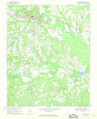
1971 Map of Cheraw
USGS Topo · Published 1976About this map
The Pee Dee River defines the eastern edge of this region, separating Chesterfield and Marlboro counties. The town of Cheraw serves as the central hub, showing a concentrated street grid that includes the Town Hall, a Hospital, and several educational institutions like Cheraw Academy and Long Jr High Sch. To the south, the expansive Cheraw State Park surrounds Eureka Lake, adjacent to the Cheraw National Fish Hatchery.
Find a feature on this map
57 named features on this map. Tap any name to fly to it.
Don’t see what you’re looking for? This feature index may not catch every label — zoom into the map to look around manually.
Map Details
Editions of this 1971 Cheraw Map
This is the sole edition of this map. No revisions or reprints were ever made.
Other maps of this area

1941 · Spartanburg
USGS Topo · 1:250,000

1942 · Rockingham
USGS Topo · 1:125,000

1953 · Florence
USGS Topo · 1:250,000

1953 · Spartanburg
USGS Topo · 1:250,000

1954 · Florence
USGS Topo · 1:250,000

1960 · Spartanburg
USGS Topo · 1:250,000

1963 · Spartanburg
USGS Topo · 1:250,000

1964 · Spartanburg
USGS Topo · 1:250,000
1968 · Chesterfield
USGS Topo · 1:24,000
1968 · Patrick
USGS Topo · 1:24,000