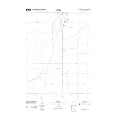
2013 Map of Cherokee South
USGS Topo · Published 2013About this map
The Little Sioux River meanders southward from the edge of Cherokee, shaping the agricultural landscape of Cherokee County. This 2013 survey illustrates the township-and-range road grid as it interfaces with the river valley and the local transportation hub at Onawa Junction. Regional infrastructure is well-defined, from the Cherokee County Regional Airport and the Cherokee County Fairground in the north to the Pearse Access area in the southwest. A notable geographic feature in the central portion of the map is Pilot Rock, accompanied by the Pilot Rock Lookout, which stands as a significant local landmark. The confluence of several waterways, including Coonley Cr, Silver Cr, and Perry Cr, underscores the importance of the river basin to the surrounding farmland and the development of local roads like Pilot Rock Rd.
Find a feature on this map
53 named features on this map. Tap any name to fly to it.
Don’t see what you’re looking for? This feature index may not catch every label — zoom into the map to look around manually.
Map Details
Editions of this 2013 Cherokee South Map
This is the sole edition of this map. No revisions or reprints were ever made.
Other maps of this area

1954 · Fort Dodge
USGS Topo · 1:250,000

1957 · Fort Dodge
USGS Topo · 1:250,000

1958 · Fort Dodge
USGS Topo · 1:250,000

1969 · Aurelia
USGS Topo · 1:24,000

1969 · Cleghorn
USGS Topo · 1:24,000

1969 · Cherokee South
USGS Topo · 1:24,000

1969 · Galva
USGS Topo · 1:24,000

1969 · Quimby SE
USGS Topo · 1:24,000
1969 · Washta
USGS Topo · 1:24,000
1969 · Quimby
USGS Topo · 1:24,000