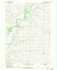
1969 Map of Washta
USGS Topo · Published 1971About this map
The Little Sioux River meanders through this western Iowa landscape, defining the character of the river valley as it was in the late 1960s. The settlement of Washta serves as a local hub, supported by the Illinois Central railroad corridor which tracks north toward Quimby. This period reveals a rural community anchored by small rural schools like Willow Sch and numerous public spaces including Ranney Knob County Park and Stieneke Area County Park.
Find a feature on this map
27 named features on this map. Tap any name to fly to it.
Don’t see what you’re looking for? This feature index may not catch every label — zoom into the map to look around manually.
Map Details
Editions of this 1969 Washta Map
This is the sole edition of this map. No revisions or reprints were ever made.
Other maps of this area

1954 · Fort Dodge
USGS Topo · 1:250,000

1957 · Fort Dodge
USGS Topo · 1:250,000

1958 · Fort Dodge
USGS Topo · 1:250,000

1967 · Holstein
USGS Topo · 1:24,000

1969 · Pierson
USGS Topo · 1:24,000

1969 · Fielding
USGS Topo · 1:24,000

1969 · Correctionville
USGS Topo · 1:24,000

1969 · Cherokee South
USGS Topo · 1:24,000

1969 · Cushing
USGS Topo · 1:24,000

1969 · Quimby SE
USGS Topo · 1:24,000