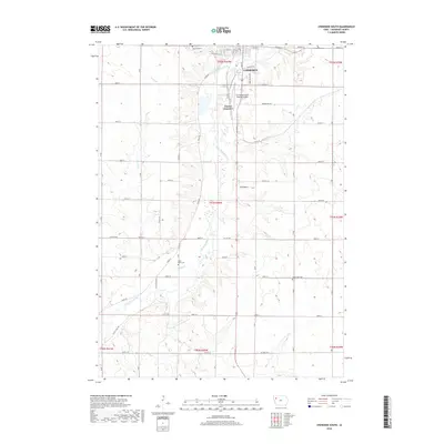
2018 Map of Cherokee South
USGS Topo · Published 2018About this map
The Little Sioux River carves a winding path through this western Iowa landscape, anchoring the city of Cherokee as it appeared in 2018. The map details the transition from the structured street grid of the town—including routes like Linden St and E Main St—to the expansive agricultural sections defined by a precise network of rural roads such as Co Hwy C43. Along the river valley, topographic relief is most pronounced near Pilot Rock, a distinctive landmark in an otherwise gently undulating terrain. Local history and genealogy are well-represented by several burial grounds, including Oak Hill Cem on the northern edge of the city, West Point Cem near Perry Cr, and Good Hope Cem to the east. Transportation infrastructure is central to the area's layout, featuring the Cherokee County Regional Airport and the rail-oriented Onawa Junction.
Find a feature on this map
77 named features on this map. Tap any name to fly to it.
Don’t see what you’re looking for? This feature index may not catch every label — zoom into the map to look around manually.
Map Details
Editions of this 2018 Cherokee South Map
This is the sole edition of this map. No revisions or reprints were ever made.
Other maps of this area

1954 · Fort Dodge
USGS Topo · 1:250,000

1957 · Fort Dodge
USGS Topo · 1:250,000

1958 · Fort Dodge
USGS Topo · 1:250,000

1969 · Aurelia
USGS Topo · 1:24,000

1969 · Cleghorn
USGS Topo · 1:24,000

1969 · Cherokee South
USGS Topo · 1:24,000

1969 · Galva
USGS Topo · 1:24,000

1969 · Quimby SE
USGS Topo · 1:24,000
1969 · Washta
USGS Topo · 1:24,000
1969 · Quimby
USGS Topo · 1:24,000