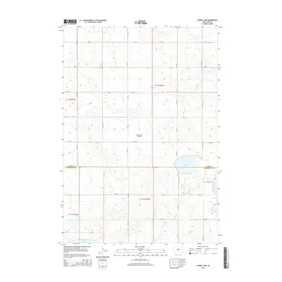
2015 Map of Cherry Lake
USGS Topo · Published 2015About this map
The Coteau des Prairies plateau defines the geography of this Eastern South Dakota landscape, a region characterized by its distinctive glacial topography and high concentration of prairie potholes and basins. This survey of the border between Clark and Kingsbury counties showcases a rural network of section-line roads, including 196th St which serves as the county divide. The hydrology is dominated by three significant bodies of water: Cherry Lake, Plum Lake, and the northern reaches of Spirit Lake. This 2015 edition provides a precise view of the local grid system, where routes like Plum Lake Rd and Ash St navigate around the natural depressions and marshy terrain that define this upland region. The map reflects the enduring agricultural layout of the townships, where land is divided into systematic blocks punctuated by these permanent and seasonal water bodies.
Find a feature on this map
24 named features on this map. Tap any name to fly to it.
Don’t see what you’re looking for? This feature index may not catch every label — zoom into the map to look around manually.
Map Details
Editions of this 2015 Cherry Lake Map
This is the sole edition of this map. No revisions or reprints were ever made.
Other maps of this area

1899 · De Smet
USGS Topo · 1:125,000

1953 · Watertown
USGS Topo · 1:250,000

1958 · Watertown
USGS Topo · 1:250,000

1968 · Erwin
USGS Topo · 1:24,000

1971 · Bancroft East
USGS Topo · 1:24,000

1971 · De Smet
USGS Topo · 1:24,000

1973 · Willow Lake
USGS Topo · 1:24,000

1973 · Bryant
USGS Topo · 1:24,000

1973 · Vienna West
USGS Topo · 1:24,000
1973 · Cherry Lake
USGS Topo · 1:24,000