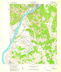
1958 Map of Cheshire
USGS Topo · Published 1959About this map
The Ohio River corridor north of Point Pleasant serves as a busy industrial and institutional hub in the late 1950s. The landscape is defined by the heavy presence of the Chesapeake and Ohio and Baltimore and Ohio railroads, which support local industry indicated by a tipple and several Strip Mines on the West Virginia side. Large-scale land use is prominent, notably the Clifton F McClintic State Wildlife Station and a significant U S Reservation, which sit alongside the West Virginia University Experimental Station.
Find a feature on this map
67 named features on this map. Tap any name to fly to it.
Don’t see what you’re looking for? This feature index may not catch every label — zoom into the map to look around manually.
Map Details
Editions of this 1958 Cheshire Map
This is the sole edition of this map. No revisions or reprints were ever made.
Other maps of this area

1907 · Pomeroy
USGS Topo · 1:62,500

1907 · Keno
USGS Topo · 1:62,500

1908 · Ravenswood
USGS Topo · 1:62,500

1908 · Point Pleasant
USGS Topo · 1:62,500

1926 · Ravenswood
USGS Topo · 1:62,500

1926 · Point Pleasant
USGS Topo · 1:62,500

1928 · Ravenswood
USGS Topo · 1:62,500

1929 · Point Pleasant
USGS Topo · 1:62,500

1947 · Columbus
USGS Topo · 1:250,000

1949 · Clarksburg
USGS Topo · 1:250,000