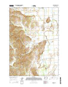
2014 Map of Cheshire
USGS Topo · Published 2014About this map
The Long Tom River winds through the eastern valley of this Lane County landscape, where the settlements of Cheshire and Franklin serve as local hubs along the Territorial Hwy. This modern 2014 survey captures a rural Oregon community defined by its proximity to both the river and the rising hills to the west, including Cox Butte and Richardson Butte. The area is particularly notable for its concentration of small family and community burial grounds, such as the Jones-Kime-Brown Property Cem and the Franklin Grange Cem, which provide significant points of interest for genealogists tracking early valley residents. Further west, the terrain transitions into more dramatic relief near Goldson, where Chris Fur Canyon and Nash Canyon cut through the timbered slopes. The map also documents the localized drainage network feeding the river, including Bear Cr, Ferguson Cr, and Amazon Creek.
Find a feature on this map
68 named features on this map. Tap any name to fly to it.
Don’t see what you’re looking for? This feature index may not catch every label — zoom into the map to look around manually.
Map Details
Editions of this 2014 Cheshire Map
This is the sole edition of this map. No revisions or reprints were ever made.
Other maps of this area

1909 · Harrisburg
USGS Topo · 1:31,680

1909 · Elmira
USGS Topo · 1:62,500

1910 · Eugene
USGS Topo · 1:62,500

1911 · Monroe
USGS Topo · 1:31,680

1912 · Halsey
USGS Topo · 1:62,500

1922 · Monroe
USGS Topo · 1:62,500

1922 · Elmira
USGS Topo · 1:62,500

1939 · Monroe
USGS Topo · 1:62,500

1940 · Eugene
USGS Topo · 1:62,500

1941 · Halsey
USGS Topo · 1:62,500