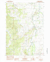
1984 Map of Cheshire
USGS Topo · Published 1984About this map
Long Tom River meanders through the heart of this Lane County landscape, defining the agricultural and settlement patterns of the mid-1980s. The valley floor is marked by small rural communities like Cheshire and Franklin, where the Territorial Sch and Franklin Cem serve as focal points for local history and genealogy. The terrain transitions from the river's flat floodplains, including Lingo Slough and Coyote Creek, into the rising foothills of the Coast Range to the west. Evidence of the region's transport evolution is visible in the Southern Pacific Railroad Grade and the route of the Territorial Highway. Distinctive landmarks such as Cemetery Butte and Cox Butte rise above the basin, while smaller settlements like Goldson and Ferguson are tucked away along tributary drainages like Owens Creek and Nails Creek, illustrating a classic Pacific Northwest pattern of valley-bottom farming and timbered upland draws.
Find a feature on this map
42 named features on this map. Tap any name to fly to it.
Don’t see what you’re looking for? This feature index may not catch every label — zoom into the map to look around manually.
Map Details
Editions of this 1984 Cheshire Map
This is the sole edition of this map. No revisions or reprints were ever made.
Other maps of this area

1909 · Harrisburg
USGS Topo · 1:31,680

1909 · Elmira
USGS Topo · 1:62,500

1910 · Eugene
USGS Topo · 1:62,500

1911 · Monroe
USGS Topo · 1:31,680

1912 · Halsey
USGS Topo · 1:62,500

1922 · Monroe
USGS Topo · 1:62,500

1922 · Elmira
USGS Topo · 1:62,500

1939 · Monroe
USGS Topo · 1:62,500

1940 · Eugene
USGS Topo · 1:62,500

1941 · Halsey
USGS Topo · 1:62,500