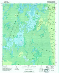
1994 Map of Chesser Island
USGS Topo · Published 1994About this map
Okefenokee National Wildlife Refuge and Wilderness dominates this portion of the Georgia swamp, where a complex network of prairies and islands defines the terrain. The landscape is marked by the presence of Chesser Plantation and the Suwannee Canal, the latter reflecting historical attempts to drain the wetlands. Navigation through the interior relies on distinctive landmarks such as Hog Island and Big Cypress Camp Island, while the eastern edge is lined with numerous family-named points and heads including Clay Point, Knot Head, and Scott Head. Near the northeastern corner, Camp Cornelia serves as a human foothold at the edge of the vast Chesser Prairie. The map illustrates the careful management of this environment through clearly delineated refuge boundaries and the trace of the Fort Perimeter Road skirting the swamp’s eastern rim.
Find a feature on this map
57 named features on this map. Tap any name to fly to it.
Don’t see what you’re looking for? This feature index may not catch every label — zoom into the map to look around manually.
Map Details
Editions of this 1994 Chesser Island Map
This is the sole edition of this map. No revisions or reprints were ever made.
Other maps of this area

1918 · Folkston
USGS Topo · 1:62,500

1918 · Moniac
USGS Topo · 1:62,500

1942 · Moniac
USGS Topo · 1:62,500

1954 · Valdosta
USGS Topo · 1:250,000

1956 · Eddy
USGS Topo · 1:24,000

1958 · Valdosta
USGS Topo · 1:250,000

1959 · Valdosta
USGS Topo · 1:250,000

1965 · Chesser Island
USGS Topo · 1:24,000

1965 · Chase Prairie
USGS Topo · 1:24,000

1965 · Blackjack Island
USGS Topo · 1:24,000