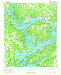
1964 Map of Chestatee
USGS Topo · Published 1965About this map
The waters of Lake Sidney Lanier dominate this mid-century landscape, where the confluence of the Chattahoochee River and Chestatee River created a complex shoreline of inlets and bays. Published just a few years after the lake reached its full pool, the map documents a transition from traditional rural agriculture to a water-based recreational economy. Established community centers like the settlement of Chestatee and landmarks like Westbrook Mountain remain, but they are increasingly defined by their proximity to new access points such as Nik Bridge Access Point and Bolling Mill Access Point.
Find a feature on this map
64 named features on this map. Tap any name to fly to it.
Don’t see what you’re looking for? This feature index may not catch every label — zoom into the map to look around manually.
Map Details
Editions of this 1964 Chestatee Map
3 editions found
Other maps of this area

1890 · Suwanee
USGS Topo · 1:125,000

1891 · Gainesville
USGS Topo · 1:125,000

1894 · Suwanee
USGS Topo · 1:125,000

1954 · Greenville
USGS Topo · 1:250,000

1955 · Rome
USGS Topo · 1:250,000

1958 · Greenville
USGS Topo · 1:250,000

1958 · Rome
USGS Topo · 1:250,000

1961 · Rome
USGS Topo · 1:250,000

1963 · Rome
USGS Topo · 1:250,000

1964 · Murrayville
USGS Topo · 1:24,000