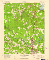
1952 Map of Chester
USGS Topo · Published 1959About this map
Colonial Heights and the village of Chester anchor this mid-century portrait of Chesterfield County's evolving transport landscape. The mapping captures a period of significant infrastructure development, most notably the introduction of the Richmond Petersburg Turnpike and its various intersections like Interchange 4, cutting through a terrain defined by the winding Swift Creek. To the north, the James River (Old Channel) loops around Farrar Island, reflecting the historical importance of the waterway alongside modern industrial markers like the Colonial Heights Waterworks and Midway Airport.
Find a feature on this map
58 named features on this map. Tap any name to fly to it.
Don’t see what you’re looking for? This feature index may not catch every label — zoom into the map to look around manually.
Map Details
Editions of this 1952 Chester Map
This is the sole edition of this map. No revisions or reprints were ever made.
Other maps of this area

1894 · Bermuda Hundred
USGS Topo · 1:62,500

1894 · Petersburg
USGS Topo · 1:62,500

1897 · Amelia
USGS Topo · 1:125,000

1938 · Dutch Gap
USGS Topo · 1:24,000

1938 · Drewrys Bluff
USGS Topo · 1:24,000

1943 · Dutch Gap
USGS Topo · 1:31,680

1943 · Chesterfield
USGS Topo · 1:31,680

1943 · Hopewell
USGS Topo · 1:31,680

1943 · Beach
USGS Topo · 1:24,000

1943 · Sutherland
USGS Topo · 1:24,000