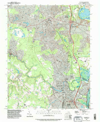
1994 Map of Chester
USGS Topo · Published 1996About this map
Chester serves as a central hub in this mid-1990s landscape, positioned where the Seaboard Coast Line and Richmond-Petersburg Turnpike intersect. The topography is defined by the sharp bend of the James River at Dutch Gap, framing Farrar Island and the neighboring Richmond National Battlefield Park. The transition from the established community of Colonial Heights northward reveals a mix of suburban development and industrial infrastructure, including numerous sewage disposal ponds and a filtration plant near Sherwood Hills.
Find a feature on this map
69 named features on this map. Tap any name to fly to it.
Don’t see what you’re looking for? This feature index may not catch every label — zoom into the map to look around manually.
Map Details
Editions of this 1994 Chester Map
This is the sole edition of this map. No revisions or reprints were ever made.
Other maps of this area

1894 · Bermuda Hundred
USGS Topo · 1:62,500

1894 · Petersburg
USGS Topo · 1:62,500

1897 · Amelia
USGS Topo · 1:125,000

1938 · Dutch Gap
USGS Topo · 1:24,000

1938 · Drewrys Bluff
USGS Topo · 1:24,000
1943 · Dutch Gap
USGS Topo · 1:31,680

1943 · Chesterfield
USGS Topo · 1:31,680

1943 · Hopewell
USGS Topo · 1:31,680

1943 · Beach
USGS Topo · 1:24,000

1943 · Sutherland
USGS Topo · 1:24,000