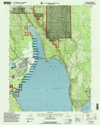
1995 Map of Chester
USGS Topo · Published 1997About this map
The northern reaches of Lake Almanor dominate this mid-1990s landscape, where the North Fork Feather River feeds into the reservoir near the settlement of Chester. As a hub for both aviation and local industry, the area is defined by the Chester Airport & Heliport and the surrounding timberlands of the Lassen National Forest. The town layout shows a mix of civic infrastructure, including Sewage Disposal Ponds and the Gaging Station near the river's mouth, illustrating the managed water systems critical to the region's hydroelectric and recreational economy.
Find a feature on this map
41 named features on this map. Tap any name to fly to it.
Don’t see what you’re looking for? This feature index may not catch every label — zoom into the map to look around manually.
Map Details
Editions of this 1995 Chester Map
2 editions found
Other maps of this area

1886 · Lassen Peak
USGS Topo · 1:250,000

1892 · Lassen Peak
USGS Topo · 1:250,000

1894 · Lassen Peak
USGS Topo · 1:250,000

1955 · Almanor
USGS Topo · 1:62,500

1955 · Westwood
USGS Topo · 1:250,000

1956 · Mt. Harkness
USGS Topo · 1:62,500

1956 · Chester
USGS Topo · 1:62,500

1958 · Westwood
USGS Topo · 1:250,000

1958 · Jonesville
USGS Topo · 1:62,500

1959 · Westwood
USGS Topo · 1:250,000