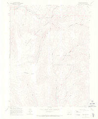
1967 Map of Chester
USGS Topo · Published 1969About this map
The Continental Divide snake across this high-elevation landscape in the late 1960s, marking the boundary between the Gunnison National Forest and the Rio Grande National Forest. The map documents a rugged transition zone where the Cochetopa Hills meet notable summits like Windy Peak. A striking historical remnant is the Old Railroad Grade in the northern sector, passing through the small settlement at Chester and near Tank Seven. This abandoned infrastructure, along with several stretches of Pack Trail and a Jeep Trail, illustrates the difficult transportation routes required to navigate the high alpine parks like Sawmill Park and Cameron Park. The drainage network is complex, including the headwaters of Marshall Creek, Middle Creek, and Deadmans Creek, which carve deep into the mountainous terrain.
Find a feature on this map
28 named features on this map. Tap any name to fly to it.
Don’t see what you’re looking for? This feature index may not catch every label — zoom into the map to look around manually.
Map Details
Editions of this 1967 Chester Map
3 editions found
Other maps of this area

1956 · Montrose
USGS Topo · 1:250,000

1959 · Montrose
USGS Topo · 1:250,000

1959 · Bonanza
USGS Topo · 1:62,500

1960 · Montrose
USGS Topo · 1:250,000

1964 · Sargents
USGS Topo · 1:24,000

1967 · Sargents Mesa
USGS Topo · 1:24,000

1967 · Trickle Mountain
USGS Topo · 1:24,000

1967 · Lake Mountain NE
USGS Topo · 1:24,000

1967 · Chester
USGS Topo · 1:24,000

1967 · Pahlone Peak
USGS Topo · 1:24,000