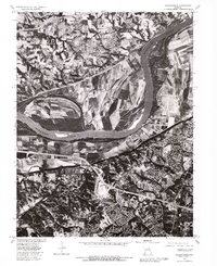
1979 Map of Chesterfield
USGS Topo · Published 1981About this map
Missouri River meanders through the heart of this 1979 orthophotoquad, serving as a stark dividing line between the developing suburban landscapes and the expansive agricultural floodplains. To the south, the community of Chesterfield and the residential corridors around Bellefontaine show the distinct patterns of late-twentieth-century growth, with winding street networks and expanding infrastructure. In contrast, the northern bank reveals the intricate field patterns of the Missouri bottomlands near Howell and Harvester. This orthophoto provides a unique visual perspective, blending the precision of a topographic survey with the raw detail of aerial imagery, capturing the exact state of land use, forest cover, and river morphology at the end of the 1970s. It is particularly useful for observing how development was beginning to encroach upon the traditional rural character of the St. Louis metropolitan fringe.
Find a feature on this map
5 named features on this map. Tap any name to fly to it.
Don’t see what you’re looking for? This feature index may not catch every label — zoom into the map to look around manually.
Map Details
Editions of this 1979 Chesterfield Map
This is the sole edition of this map. No revisions or reprints were ever made.
Other maps of this area

1903 · O'Fallon
USGS Topo · 1:125,000

1924 · Robertson
USGS Topo · 1:24,000

1927 · St. Charles
USGS Topo · 1:62,500

1931 · Manchester SE
USGS Topo · 1:24,000

1931 · Brussels
USGS Topo · 1:62,500

1932 · Manchester NE
USGS Topo · 1:24,000

1933 · Creve Coeur
USGS Topo · 1:24,000

1933 · Saint Charles
USGS Topo · 1:62,500

1933 · Kirkwood
USGS Topo · 1:24,000

1937 · Weldon Spring
USGS Topo · 1:24,000